
|
|
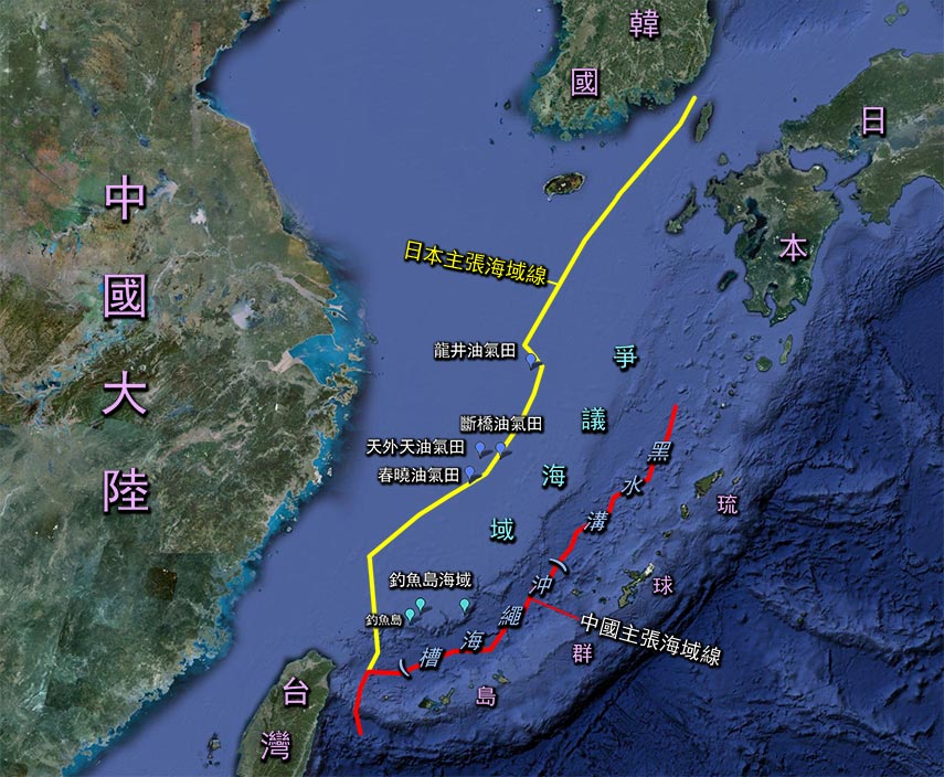
釣魚台在哪兒?有何地緣特點? 釣魚台列嶼指5個無人島、3個岩礁,總面積約6平方公里;位於台灣東北部,是大屯山脈的延伸,與台灣同屬東海水深不足200公尺的大陸棚(架)島嶼。釣魚台的東側為大陸棚的終點,以一道水深達2500公尺的“黑水溝”(亦稱沖繩海槽,非指台灣海峽)與寬闊海槽另一側的琉球群島相隔。自明、清開始迄今,中國普遍視“黑水溝”為中、琉之界。
日本一方主張釣魚台為其領土,所衍生的領海、專屬經濟區大幅往西擴展,納入整個黑水溝与釣魚台海域。中、日兩方所定的海域線,構成相當6個台灣面積的重疊爭議區。 如此大片領土、權利區一旦淪失,無論對中國國防安全、資源開發,或漁民生計,都產生巨大影響。譬如,日本可把釣魚台當作跳板,進逼大陸及臺灣,不過是一箭之遙,涉水而過。
歷史上釣魚台與我們有何淵源? 釣魚台遠自明朝已有中文命名。1372年琉球國開始朝貢後,諸多中國册封使途經釣魚台前往琉球時都留有該島嶼的航海記錄;此外還有多種海防圖將釣魚台納入邊防勢力範圍。清康熙1683年以降,台灣納入中國版圖,正式把黑水溝定為中、琉之界;同時若干地方志與府志(如《台灣府志》、《重篆福建通志》)均指出釣魚台隸屬台灣府宜蘭縣管轄(時稱噶瑪蘭廳)。除中方史料外,許多十九世紀法、英、美地圖也將釣魚台明確劃入中國版圖。如此大量中、外史料,再加上中國漁民生計長期靠此漁場依存,展示六百多年來該島群不僅與我們關係密切,甚至早已形成不可切割的有機體。
迄今,日方不顧中方的大量史料證據,卻以中方的個別地圖、文字記錄並沒“概括釣魚台”,或具體指出為“中國所有” ,而對中方的史料一概否定。我們必須說明,古時的史料不可能樣樣周全,因此日方不得忽視大端、斷章取義,或歧視性選擇少數最不完整的史料進行詭辯。至為關鍵的是,日、琉方所能展示的同時期史料,要麼證明釣魚台與其無缘;要麼證明它屬中國所有。
釣魚台是如何遭人竊取的? 歷史上,釣魚台這個守護黑水溝的前哨,先後兩次遭強權竊取,且都對中方權益產生嚴重影響:
第一次發生於1879年日本侵佔琉球(沖繩)之後。此時日本首次發現釣魚台的存在,繼而產生覬覦之心。日方經初步調查,知悉早有中文命名,同時獲知己方的暗中調查與登島行動,已為中方所警覺。於是1885年10月21日,日本外務卿井上馨便對內務卿去函稱“清國報紙等盛載我政府佔據台灣附近的清國屬島之傳言,對我國懷有猜疑。於此頻頻敦促清政府注意之際,我們若遽爾公然建立國標,反易招致清國之猜忌…至於建立國標之事,須俟他日時機。請諸位注意,已調查大東島一事及此次調查之事,恐均不刊載官報及報紙為宜…。”
十年之後,即1894年甲午戰爭爆發,井上馨久候的“時機”終於隨中方戰敗來臨。次年1月14日,日本內閣通過決議將釣魚台劃歸沖繩縣管轄,此時距 4月17日簽訂割讓台、澎的“馬關條約”僅3個月。
問:日方據此認為他們佔領的是無主島,與“馬關條約”無關,因此不屬“開羅宣言”規定的“日本該放棄的領土”。是這樣嗎? 日本為避免引起爭議,將釣魚台劃入版圖後,對外密不宣佈,甚至1896年3月的天皇敕令及同年12月的八重山行政區詳表均未納入釣魚台。為掩人耳目,1900年又私下改其名為“尖閣列島”。彼時國際社會的 “無宣佈義務”僅僅涉及佔領無主島,而釣魚島卻為中國領土,因此實際構成竊取行為。中國不知情之下,自然認為該屬島會依“馬關條約”隨台灣一併割與日本。二戰結束時,不論是於情、於理、於法,或竊取,或割讓,都應當按“波茨坦公告”的無條件投降規定,以及,依照“開羅宣言”有關“在中國所竊取之領土,如滿洲,台灣及澎湖群島等歸還中華民國”的安排,將釣魚島歸還原主,恢復中、琉以黑水溝為界的常態。
第二次釣魚台受侵犯發生於二戰末期,美國先是對琉球進行軍事佔領。由於戰後國際局勢激烈轉變,為了對共產集團進行圍堵,便開始扶持與利用日本,於1951年召開了沒有中方兩岸政府參加的“舊金山會議”。這個不為中國政府承認的會議,通過了所謂的“舊金山和約”,其中第3條做出“北緯29度以南的西南諸島等交由聯合國託管,而美國為唯一施政當局”的規定。“北緯29度以南的西南諸島”是個籠統地理概念,大體指琉球群島,並不涉及附屬台灣的釣魚台。
1953年12月25日,美國為了把琉球北端的奄美群島當作“聖誕禮物”歸還日本,刻意通過第27號令,重新制定了託管區範圍,其中,把奄美群島剔除出去的同時,把釣魚台卻給加入託管範圍。此舉為單方行動,不具任何法律依據,甚至抵觸《聯合國憲章》第七十八條 “凡領土已成為聯合國之會員國者,不適用託管制度…”的規定,對中方自然無效。當時韓戰驚魂未定,兩岸鬩牆也日趨緊張,於是次年國民政府又與美國簽訂了“共同防禦條約”,協防台灣海域,因此國民政府一方也不可能料到十多年後協防措施會節外生枝,造成1968年醞釀美國“把釣魚台行政權隨琉球歸還日本”的局面。
問:為何日方一再指出兩岸戰後發行的若干地圖與報導“承認釣魚台為日本所有”? 這種主張是避重就輕、歧視性選擇資料的故技重施。首先,1947年後,中國先後處於國共鬩牆、兩岸割據,與周邊地區發生嚴重軍事衝突的緊張局面,因而無暇顧及釣魚台這彈丸之地;此外,日本更其名為“尖閣列島”,中方並未認知“此即釣魚台”;再者,我方出版物受日本資料的誤導,實際上還是受日本侵略之影響所致;更何況,日方對己不利的類似製圖與報導,也比比皆是。
問:我們的底線為何? |
Where Are The Diaoyu Islands? What Are Their Geographic Features?
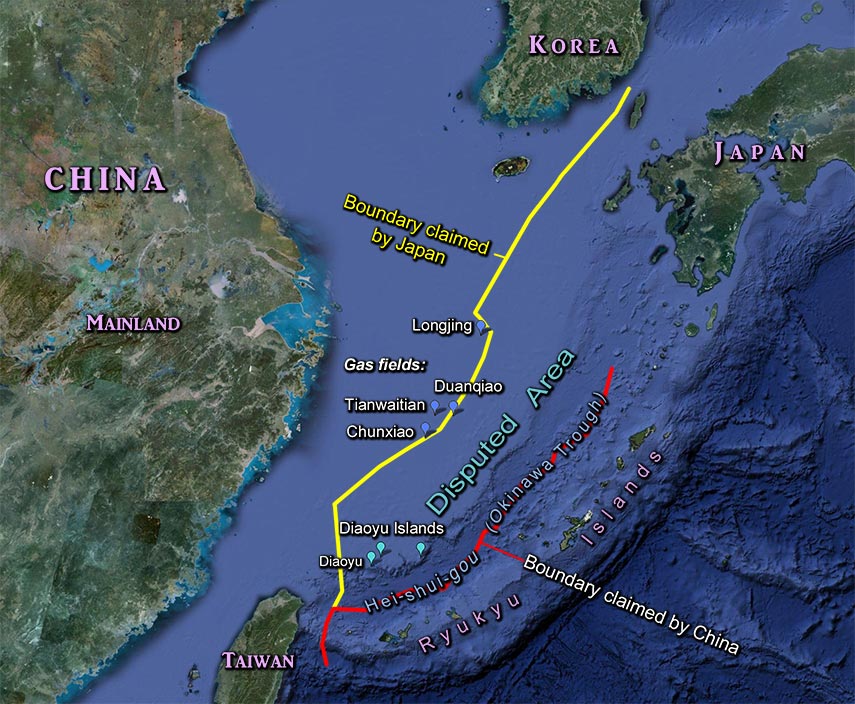
Diaoyu Islands consist of 5 uninhabited islands and 3 rock formations with a total area of 6 square kilometers. Diaoyu Islands are located offshore northeastern Taiwan, an extension of Datun mountain range. Together with Taiwan they belong to the island group of the continental shelf in the East China Sea with water depth less than 200 meters. Further to the east is the termination of the continental shelf with bathymetry reaching 2500 meters known as “Hei-Shui-Gou”, or “Black Water Trench” (also known as Liuqiu (Okinawa) Trough), which is not the Taiwan Strait; and separates Diaoyu Islands from the Ryukyu Islands on the other side of the trough. Historically ever since Ming and Qing Dynasties till today, China has always viewed the “Black Water Trench” as the boundary between China and Liuqiu (or Ryukyu), which was a China tributary state with local sovereignty.
Japan unilaterally claims Diaoyu Islands (renamed as Senkaku Islands in 1900) as her territory with the intent to extend westward a sea territory to include the “Black Water Trench” and Diaoyu Islands as her Exclusive Economic Zone (for fishing and other rights). The disputed region bounded by the Chinese and Japanese defined boundary lines is equivalent to an area of 6 Taiwan. The loss of such a giant size territory and its economic rights would be a devastating impact to the national defense, economic development of resources and the livelihood of Chinese fishermen who have been living by these waters for centuries. After capturing Diaoyu Islands, Japan would be able to block off all fishing boats from Taiwan and coastal provinces of China and use the islands as a jumping board to launch attacks to both Taiwan and Mainland China since the separation would be only a narrow strip of water.
What Does History Say About Diaoyu Islands In Relation To Chinese People?
Chinese as far back as Ming Dynasty has named Diaoyu Islands. Since 1372, when Ryukyu began to pay tribute and seek protection and blessing from Ming emperors, the Chinese diplomat delegations sent by the Emperor had traveled by Diaoyu Island and recorded it in their navigation diaries. There were also several defense maps, which had recorded Diaoyu Islands within the defense territory. Since 1683, Qing Dynasty Emperor Kangxi had included Taiwan in Qing’s sovereignty and formally designated the “Black Water Trench” as the boundary between China and Liuqiu (Ryukyu). In the same time frame, there were many local governmental records (such as the Gazetteer of Taiwan Prefecture and the Revised Gazetteer of Fujian Province) had documented that Diaoyu Islands were under the governance of Yinan County (then called Kavalan County) of Taiwan . Besides these Chinese documents, many nineteenth century maps produced by France, Britain and America had also clearly documented that the Diaoyu Islands are part of Chinese territory. Based on so much Chinese and Western historical documents and the fact that numerous Chinese fishermen lived by and fished in the ocean region of Diaoyu Islands, we can show with ample evidence that the Diaoyu Islands were not only part of China over six hundred years, but more as inseparable and integral part of the Chinese people.
Today, Japan, ignoring the vast amount of evidence, purposely sought for certain individual maps or documents, which did not include Diaoyu Islands or did not print the word “Chinese Territory”, to deny the legitimate Chinese claim on Diaoyu Islands. We must point out that not all historical documents can be expected to be complete or in anticipation of thievery centuries later, hence, it is laughable that Japan can ignore the majority of historical evidence to single out the incomplete pieces of documents to serve her purpose of stealing Diaoyu Islands. Most importantly, we can further point out, many of the Japanese or Liuqiu (Ryukyu) historical documents at that time all indicated that Diaoyu Islands plainly belonged to China and had nothing to do with Japan nor Liuqiu (Ryukyu).
How Was Diaoyu Islands Stolen?
Historically, the Diaoyu Islands, the point guard of “Black Water Trench” had been stolen twice with serious violation of the sovereign rights of China:
The first thievery occurred in 1879, after Japan invaded and occupied Ryukyu. At that time, Japan first discovered the existence of Diaoyu Islands and began a thievish plot. Japan started an ‘investigation’ of these islands; Japan found out that the islands had been named by China and their secret ‘investigation’ was known to Qing Dynasty. Hence, on October 21, 1885, the Japan Foreign Minister Inoue Kaoru wrote to Home Minister Yamagata Aritomo and said: “Qing newspapers reported the rumor of our (Japanese) exploring of Qing’s islands near Taiwan and began suspicious of Japan’s intention. While the media is alerting the Qing government, if we would start to make national markers on those islands that would increase their suspicion…As to establish national markers, it would be better to wait for later opportunities. Please pay attention, it is better not to publish the previous ‘investigation’ of Daito-jima and the current ‘investigation’ in any official publication and newspaper…”
Ten years later, the 1894 Sino-Japan war broke out, Inoue Kaoru long awaited opportunity came with China’s defeat imminent in that war. On January 14th, next year, the Japanese cabinet passed a resolution to incorporated Diaoyu Islands to be included into the Okinawa Prefecture; this took place merely three month prior to signing the “Maguan Treaty (Shimonoseki Treaty)” on April 17th in which China had ceded Taiwan and Penghu and associated small islands including Diaoyu Islands to Japan.
According to the Japanese plot, Japan claims what they occupied were terra nullius (or land without owner), not part of the islands given to Japan out of “Shimonoseki Treaty”, therefore, the Diaoyu Islands would not be considered as part of the occupied territory Japan had to return to China based on “The Cairo Declaration (1943)” which was also legally incorporated in “The Potsdam Declaration (1945)” when Japan accepted it and declared unconditional surrender to China. So, is Japan’s claim valid?
No, this is not a valid claim; in fact, it is clearly a thievery. After Japan’s cabinet’s decision of stealing Diaoyu Islands, Japan never made any public announcement so to avoid arousing China’s objection. Even in the Japanese Imperial Decree, March 1896, of declaring forming the Okinawa Prefecture, and the official administration definition of Yaeyama County (part of Okinawa), December 1896, Diaoyu Islands had never been included. Hiding this thievery, Japan renamed Diaoyu Islands as Senkaku Islands in 1900. At that time, the international practice of “no obligatory announcement” of claimed territory only applied to unclaimed islands, but Diaoyu Islands were clearly property of China; hence, Japan’s action definitely constituted as thievery. China, not knowing Japan’s plot, naturally assumed that Diaoyu Islands, as part of Taiwan, ought to be ceded to Japan according to the “Shimonoseki Treaty”. After WW II and Japan’s unconditional surrender, no matter whether Diaoyu Islands were stolen by Japan or given to Japan by force, they should be unconditionally returned to China according to the Potsdam Declaration and the Cairo Declaration. These documents dictated Japan to return all Chinese territories taken by her such as Manchuria and Taiwan and Penghu island groups reestablishing the “Black Water Trench” boundary between China and Liuqiu (Ryukyu).
Japan’s second attempted thievery of Diaoyu Islands today can be traced back to the end of WW II. Post WW II, US concerned with the rapid expansion of communism, strategically occupied Ryukyu and helped to rebuild Japan from her defeat and used her to curtail communist Soviet Union and China. In 1951, US held the “San Francisco Peace Conference” without the participation of either Republic of China or People’s Republic of China. This conference passed the San Francisco Peace Treaty which stated, in its Article 3, all islands located south of latitude 29 degree North will be under UN trusteeship and US is the designated trustee for these islands. This vague description broadly defined the Ryukyu Islands but not included the Diaoyu Islands.
In December 25th, 1953, US passed no. 27th executive order to redraw the territory of her trusteeship by offering the Amami Islands (north of Okinawa) to Japan and included Diaoyu Islands into the US trusteeship. This unilateral action had no legal basis and violated UN Constitution article 78, “any territory belongs to an UN member can not be placed under trustee system ...”, hence has no binding on China. At that time, Korean War just ended and Taiwan and Mainland China were in severe tension, thus US and Taiwan signed a mutual defense treaty. Unpredictable as it might, it was unfortunate that the mutual defense arrangements between US and Japan and US and Taiwan had led US to give the administrative rights of Diaoyu Islands and Ryukyu to Japan in 1968.
Why Japan Repeatedly Pointed Out Some Chinese Maps and Reports Published Post WW II “Recognize Diaoyu Islands belonging to Japan”?
This claim is invalid, it is simply the same trickery by selectively picking documents to suit Japan’s thievish plot. Since 1947, China was divided, struggling from economic turmoil on both sides and facing tension and hostility, hence paid little attention to the tiny Diaoyu Islands. Furthermore, Japan has confused the world by renaming the island to be Senkaku and misguided some publications causing more confusion. Nevertheless, Japan also had numerous publications in contradiction and being unfavorable to Japan’s own claims. Among all maps published, overwhelming majority indicated correctly that Diaoyu Islands are part of China.
What Is Our Basic Attitude?
Today, Japan not only violated the Potsdam Declaration, which dictated that Japan’s sovereignty is limited to the four principal islands: Honshu, Hokkaido, Kyushu, Shikoku, and the small islands defined by the Allied Nations; but also continuously exhibited territorial aggression towards neighboring countries and made serious challenge to the WW II peace treaty.
Japan’s treacherous behavior and aggression towards Chinese territory has caused all Chinese across the strait and overseas to be furious, like an emotional volcano, suppressed more than 100 years, exploded. This sentiment was not only brewed by Japan's war crimes against the Chinese people but more so by the extreme cruelty, humiliation and shame the Japanese applied to the occupied Chinese. In addition, the Japanese government and its emperor showed no remorse or apology and consistently white washed their criminal acts in their textbooks. The current worldwide protests against Japan including the efforts of UN Human Rights Commission in recent years are demanding justice. What is our sacred cause? It is to take back our Diaoyu Islands and defend the ocean boundary of our “Black Water Trench”, or, the “Hei-Shui-Gou” – This is our unchallengeable historical task.
|